There are some remnants of the Rio Grande Southern which are still standing.
If you are interested in seeing some of these remnants, then the following information
should help you locate them.
Out Along the Line
Ridgway
Ridgway is located on Hwy 62 just west of the intersection with Hwy 550. Just before
driving into the town proper, look to your right. The depot has been converted into a
house and is very well maintained.
Image of the Ridgway Depot
Just before you leave town on Hwy 62, near what is a bus yard I think, take the
road to your right, which will drift down into the valley. After about half a mile
or so you will cross the old right-of-way. To the right, back towards town, about
a quarter of a mile from the road is the site of the original engine yard and
facilities. Still quite a lot there, including the roundhouse foundations and pits,
lines of ties (without rails of course), some tie plates and spikes (etc).
As this is on private property, make sure you ask the owner, Brian Kolovich, for
permission to walk the site. Brian is a local realtor whose office is next to the
sandwich shop with the outside decking back in town on Hwy 62.
Omega
The Omega aerial tramway terminal used to be found alongside Hwy 62, about
two miles north of Placerville. Unfortunately this was removed a few years ago
when a housing development was in the wind. You can still see the upper tram
house high up on the cliff though.
Driving through this area you will cross over Dallas Divide. This is a beautiful
strech of mountains as shown in the image here.
Placerville
Located on Hwy 145 near where it intersects with Hwy 62 is Placerville. Quite a
few things still remain in this area.
The depot has been split into three sections. One section is located, one street
up the hillside, parallel with the Hwy. Another section has been added onto the
old Post Office (next to the General Store), whilst the last section is now a
residence just north of the General Store.
Image of the Placerville Depot
The RGS freighthouse/warehouse still stands right along side the highway, whilst
the Texaco and Conoco bulk-oil depots can still be found right near the junction of
Hwys 62 & 175. (Just heard that the warehouses have been removed and the whole
area paved over. June 1999).
Image of Warehouse 1
Image of Warehouse 2
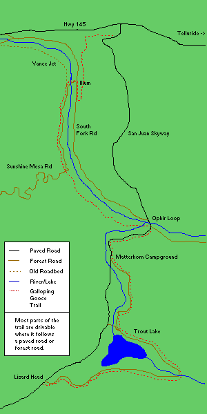
Sawpit
Travel south from Placerville on Hwy 145. A couple of miles past Placerville keep
an eye out on the right hand side for an ore tipple. A dirt road leads off the highway
for a hundred yards or so to the tipple.
This tipple is currently under restoration. Thanks to Fritz Klinke of the primary
contractors performing this work, for the update. The contractors have resecured the
cables on a new anchor system, and are raising the structure itself to be put on a
new base of timbers. It will also be re-roofed, and new siding installed for the top
section.
Image of the ore tipple
A section of the roadbed south of Vanadium
Vance Junction
To get to Vance Junction, look for the forest access road for "Ames". Follow this
road until you sight the remains of the coal tipple which is all that's left.
The Forest Service is apparently restoring the tipple to stop it "disappearing"
entirely. Good on 'em.
Coal Tipple from across the river
Close up of the Coal Tipple
And an even closer one
And an even closer one
Bridge footings just north of Vance Junction
Ames
There was once a water tank and a high trestle bridge near the slide at Ames. Now
little remains but the roadbed and a few hoops
left from the water tank.
Ilium
At llium the R.G.S placed a wye to turn trains in the
Vance Junction area. Two legs of the wye had to cross the
creek and were on small timber bridges. The bridge at
the south leg of the wye is still standing , whilst only
the bridge abutments for the north leg can be seen.
The Keystone Hill section of the Galloping Goose trail
starts on the east side of the road to Ames, less than a
mile south of the Ilium site. It is marked by a sign with
a trail map. Just to the west of where the road meets the
start of this trail, the grade crossed the river on a
trestle whose footings are almost gone. However, the
approaches to the trestle on both sides of the river are
obvious. This was the southernmost point of the Ilium
loop.
Also, after crossing the road bridge to the Ilium camp
from the Ames road, there is a dirt road off to the left that
follows the old grade south to the Ilium loop. A short way
down this road there are some sections of rail sitting on
the ground and sticking out of it.
A more interesting artifact near Ilium is the wreckage of
the tender of RGS locomotive #19 that ran away on Keystone
Hill in 1907. A description of this event may be found in
Josie Crum's book on the RGS. A picture is on p. 177 of
"The Silver San Juan" by Mallory Hope Ferrell. The wreckage
is just to the east of the Ames road, a little way north
of where the Keystone Hill trail starts.
Image 1 of the tender
Image 2 of the tender
Image 3 of the tender
Keystone Hill
From Ilium, the line had to climb a steep grade on the
way to Telluride. This is known as Keystone hill
This part of the Galloping Goose trail is well worth the
effort if one is in reasonable shape. The 4% grade may
have been a problem for locomotives, but it's easy
for hiking and biking. A bit too easy perhaps; a railfan
walking this grade with visions and sounds of
narrow gauge railroading dancing in his/her head will likely
have their reverie disrupted by (possibly lunatic) mountain
bikers, who like the Galloping Goose trail because it is one
of the easiest bike runs in the area. But the views to Vance
Junction to the west are worth any two-wheeled aggravation.
In fact, if you can't beat 'em, join 'em; bring your own
bike! Not many artifacts, but some ties and other telltale
signs of the old railroad are there.
Trestle location image
Image of the Keystone Hill grade
Telluride
The depot is located close to where it alway has been on South Townsend street
in Telluride. (It was moved somewhat when restored). It has been well restored and
is now a Micro-Brewery and Restaurant. A good spot for lunch (if open).
Image of the Depot
Goose #4 can be found on Colorado Avenue, tucked away in a little alcove next to
the Court House.
Image of Goose #4
If you continue on Colorado Avenue through Telluride for about a mile you will reach
the old mining complex at Pandora. The machinery may now look a bit "modern", but the
feeling this scene evokes at the end of the box canyon is still the same. Ingram
falls still look as spectacular as ever.
Image of the Pandora mill
Butterfly
From Ilium towards butterfly, the first few miles of this
route are driveable (note: it's nice to be able to drive
along the old grade and imagine you're riding a train,
but the problem is that the act of making the grade
into a road usually removes any trace of the railroad
from the route). This road (I think it's called Sunshine
Mesa Road) is definitely on the old roadbed until it
turns west steeply uphill a few miles south of Ilium.
After this point one must hoof it or bike it to continue
on the RGS grade. This additional 2-3 mile (one-way) hike
or bike is DEFINITELY worth it. This grade seems to be
largely untouched since abandonment. There are places
where it looks like ties were moved to one side or the
other to make the path more passable, but in most places
the remnants were left as is. And there are lots of them;
the Ames siding is easy to find. The walk to Windy Point
across the Ames slide (and others) is spectacular, with
the Ophir Needles across the valley to the east. The Ames
trestle remains are there; an easy path around them is
provided. The trail rounds Windy Point and goes on to
Butterfly, the site of the trestle leading to the Ophir
Low Line. A new footbridge is provided to cross there
which allows people to get across to the Low Line.
Note: there are seasonal streams that cross this path;
They may only be few inches deep, but certainly enough
to make your feet uncomfortable for the rest of the walk
if you didn't take your shoes off. I'd recommend a bike,
which can be ridden through such obstacles.
Image of Windy Point
Ophir
Between Placerville and Trout Lake look for the side road which directs you to
"Old Ophir". Stop on the side road. This is the location of the Ophir loop.
Image of the RGS roadbed on the way to Ophir
The Highway now covers the old station depot, but the Silver Bell mine can be seen
and the "Gilton Club" building which stood in Ophir during the railroad era still exists.
(Except now instead of being above the railroad grade, it is well below the grade of the
highway).
Image of the Silver Bell Mine
Image of the Gilton Club
The trestle bents for bridge 45A can be seen below Ophir, although obviously not
in "standing" condition.
Image of bridge 45A's footings & remains
Images looking down on the high line and the low line from the highway.
Roadbed
Bridge Remains
High Line Bridge Remains
Surprisingly, the entire Low Line and part of the High Line
are driveable (given care and/or reasonable clearance).
An unmarked dirt road drops steeply off the west side
of the highway at Ophir Loop; a little way down this
road there is a sign warning that private property is
on either side of the path, and to stay on it. Continue
down this road, and it crosses the High Line.
Park here, turn to the left and you can walk to the
remains of one of the bridges on the High Line. The
High Line is not passable beyond this point. You can also
walk to the right to get to the one end of bridge 45B,
the smaller of the two trestles at Ophir Loop.
Concrete Footings of Bridge 46-D
After checking out the High Line, you can continue down
the access road to the Low Line. To the right is the west
end of the long bridge 45A. To the left, you can drive
all the way to Butterfly and walk across the new footbridge
to the path described above. I didn't see much in the way
of artifacts on the Low Line.
Image of the Ophir Needles
Towards Ophir from Windy Point
Matterhorn
The Matterhorn mill can be found just off the Highway a little south of Ophir. The
RGS stopped to serve the mill and the small township that sprang up around it for much
of its life.
View of the Matterhorn mill
Another view of the mill
Trout Lake
Trout Lake is found alongside Hwy 145. (It's kind of hard to miss a lake). Turn on
to the forest access road for "Trout Lake / Lizard Head" and follow it alongside the lake.
This is the old RGS right of way.
Image of Tout Lake. Spot the water tank.
Just a little way along is the Trout Lake water tank which is in a fairly reasonable
condition. Also in this area is believed to be a coach (#252) now used as a residence.
Image of water tank
Continue along the access road until you come to the last
remaining trestle bridge. This is bridge 51A. If you continue on
along the access road you will arrive at Lizard Head Pass, where
the road rejoins Hwy 145. (Yes you can drive right through again. The bridge
which was down has been replaced with a culvert, again opening up the road).
Image of Bridge 51A
Another image of Bridge 51A
Lower angle image of Bridge 51A
Close-up of trestle bent
Close-up of the bridge ties
Note: This bridge will hopefully get some of the restoration care being shown
to other RGS sturctures such as the Vance Junction coal tipple and the ore tram at
Sawpit
Lizard Head Pass
Lizard Head Pass was one of three passes the RGS had to cross. At over 10,000 feet
it spends much of it's time under a thick layer of snow as shown in this
1998 view
Image of aproach
Another image of aproach
Gallagher Trestles
The Gallagher Trestles were two trestle bridges which
helped form a 180 degree (or so) loop of track. To fit in
the loop, the track had to cross the creek twice.
Little remains can be found in this area, although the
scenery is spectacular.
The area covered by both trestles
Image of the roadbed approaching Gallagher
Image of trestle bridge footings
Approach embankment
Close up of bridge footings
Image of the roadbed after Gallagher
Rico.
Rico is located on Hwy 145 south of Lizard Head. The only thing still standing is
the old water tank. This is located in the old yard area parallel to, and below the
Hwy. The tank is in pretty bad shape and is fenced off for protection.
Note: This structure will hopefully get some of the restoration care being shown
to other RGS sturctures such as the Vance Junction coal tipple and the ore tram at
Sawpit
Image of the Rico water tank
Image of the roadbed in Burns Canyon
Image of the Burns Canyon bridge abutments
Dolores
South of Rico on Hwy 145 is the town of Dolores. Here a replica of the Dolores depot
has been built by the Historical Society. Stop and have a look inside for items of
interest. Outside is goose #5 on a short length of track.
Image of goose #5
Another image of goose #5
Image of the rebuilt Dolores depot
Historical view of Dolores
Also in this area is coach #256 now owned by the Galloping Goose Historical
Society for restoration.
Just north of Dolores, a small trestle can be seen in a field about 60 yards in
from the Highway. (On the eastern side).
Mancos
Some items still remain in Mancos. Thanks to Jeff Pope for this information.
The depot was split in two, with the freight room section moved onto a farm
pasture north of town, along the highway to Dolores. The remainder of the depot
was incorporated into a house which stands on Riverside Ave, several blocks
south of the original location near the tracks.
One of the original bunkhouses remains, in its original location, just west
of town and along the R.R. right-of-way. It now stands in the middle of a
field, fenced off and in poor condition. Two other bunkhouse-type buildings,
originally on the north side of the tracks, across from the depot, are also
said to be still in Mancos, incorporated into a house somewhere.
East Mancos
The East Mancos water tank may still be located by those keen enough. Some help
from a topographical map of the area will definitely come in handy though. For t
hose who want to try, here are some directions:
About 18 miles west of Durango on Hwy 160 is FR316 (this is one of the forest
access roads). Last I heard, the road was marked as the "Madden Peak Road".
Turn left onto FR316 (coming from Dolores) and drive north for about 1.25 miles
until it intersects the old RGS grade. (About 1.1 miles). The grade isn't too hard
to identify, but you will need to look out for it.
From here you'll need to walk. Turn left up the grade and hike for about 1
to 1.5 miles. You'll see the tank as you get near. Beware, recent information
has a barbed wire fence running across the roadbed. If you cross this to reach
the tank, you will be trespassing, and the current owner does not appreciate
trespassers.
The East Mancos water tank
If instead of turning left up the raodbed to the East Mancos tank, you turn
right, you an travel about 6 miles. (~MP132.7-139). This is on forest road 568
You will pass the remains of the Starvation Creek trestle, (the road bypassed
the trestle). Be carefull of the time of the year or else the creek will be too
deep to cross. A 4WD is recommended for this part of the grade.
A couple of images of the grade between MP132.7 and 139
Image 1
Image 2
Image 3
Millwood
Not much left, but here's a few images of the right-of-way taken in Sept 1996.
Durango
Everybody in south west Colorado ends up in Durango. There's nothing of the RGS left
to see here, but a trip on the Durango and Silverton is still worth while.
Galloping Goose Trail #499
The U.S. Forestry Service has recently (late 1996, early 1997) turned part of the
Rio Grande Southern right-of-way into a hiking and mountain bike trail. I should thank
Don Paulson for the detailed info. It is a section of the line from Telluride,
down Keystone hill to Vance Junction, and from Vance, on up through the Ophir Loop
to Trout Lake and Lizard Head. Of course the trail is well marked with small
"Galloping Goose" signs to point the way.
Obviously not all of the trail is on the old roadbed (as some of it just doesn't
exist any more) and some of the roadbed is now part of the Jan Juan Skyway (Hwy) or a
forest access road. Anyhow this should make for some very interesting hikes through the
San Juans.
Windy Point (Looking South)
Windy Point (Looking North)
If anybody has some more information on this trail, or some photos they think would
be appropriate, don't forget to drop me a line.
Colorado Railroad Museum
The Colorado Railroad Museum is located in Golden, just west of Denver. Here they have
preserved locomotives, rolling stock and artefacts from many of Colorado's railroads,
both narrow and standard gauge.
Located in the grounds can be found the following items from the RGS.
There are probably other items here from the RGS, but I wasn't looking for them when
I was last there. If anyone knows of additional items, please
drop me a line.
Ridgway Railroad Museum
The Ridgway Railroad Museum
has recently started to put together a display of railroad artifacts in Ridgway.
Track and ties have been donated by the Durango and Silverton Railroad
and other equipment is on the way. Including a replica of Goose #1.
- Replica of Goose #1 at Silverton
- 5000 series DRGW Stock car (sheep) purchased from a private owner
in Oklahoma.
- Coach #250 (used as the Vance Jct depot), will be obtained from
the Colorado Railroad Museum.
- Believed that the RGS Modelers Club may donate a Gondola.
Galloping Goose Historical Society
The
Galloping Goose Historical Society in Dolores has restored goos #5 and has
taken her on a few runs over both the Cumbres and Toltec, and the Durango
and Silverton railroads.
Knottsberry Farm
This amusment park obtained narrow gauge locomotives and equipment from lines as
they were closing down in the 1950's. They were used for a steam train ride around the
park.
I'm sure there is more than this from the RGS at the park. If you know what else
is there, please let me know.
Durango and Silverton
The Durango and Silverton Narrow Gauge Railroad have a few items of RGS equipment.
Notably:
- Locomotive #42 (2-8-0 - Non operational)
- Coach #257 (Fully restored & operational)
Wagon Wheel Gap Project
A group of volunteers have purchased and are restoring the old line up
through Wagon Wheel Gap to Creede. See there progress at thier web site:
Wagon Wheel Gap Route of the D&RGW
Others
- RGS Locomotive number 74 (from the CS and other roads) is currently in a municipal
park in Boulder CO.
- Caboose #0400 is on display in Georgetown.
- Coach #260 is now at the Huckleberry Railway in Flint Mich.
- Reefer #2101 (ex C&S 1113) is now at the Sundown & Southern RR. This is a
private 3' RR camp (now non operating), near Hudson, Colorado.
Click Here to check out
the web site.
Further Information
If anyone has any further information on where remnants of the RGS can be found,
then please let me know and I'll include it here.
References
 >
>